


Map of Roman Britain
The Roman roads in Britain were constructed between approximately AD 50 and AD 400, in order to facilitate trade and military traffic between the different regions of Roman Britain (Britannia). There were no proper roads in Britannia prior to the arrival of the Romans. Instead, the native Brythons used trackways which were often located along hilltop ridges, such as the Ridgeway in southern England. Some of these trackways were later adapted by the Romans, but most of the road network was wholly new.
In southern Great Britain, Roman roads fell into disrepair in the Early Middle Ages, during which time they gained their present names. In some places, the origins of the roads were forgotten and they were ascribed to mythical Anglo-Saxon giants and divinities: for instance, Wade's Causeway in North Yorkshire owes its name to Woden, the supreme god of Germanic and Norse mythology.
The roads continued to be used for centuries thereafter. Chaucer's pilgrims in the Canterbury Tales almost certainly used Watling Street to travel from Southwark to Canterbury. However, the roads were mostly destroyed in the 18th and 19th century when toll roads were constructed on top of the Roman originals. Very few Roman roads have survived in anything like their original condition, and even then only for very short stretches - Wade's Causeway is widely regarded as the best-preserved in Britain. Many modern roads continue to use the old Roman alignments. Much of Watling Street, for example, is now under the A2 and A5.
The Roman engineers who constructed BritainТs first roads built them to a standard pattern replicated across the empire. Military roads tended to follow long, straight alignments between major towns and garrisons, while civil routes tended to follow the contours of the land in order to link farms and estates to their markets. The road was carried on an embankment (the agger), sometimes as much as 5 feet (1.5 m) high and 50 feet (15 m) wide, built up from soil excavated from drainage ditches on either side of the road. The road was surfaced with gravel wherever possible, but small broken stones or larger blocks or slabs were used if gravel was in short supply.
Many English place names derive from a position on or near a Roman road, usually denoted by the element -street (also strat-, strait-, streat- and other variants). Thus, for example, Stretham means Уhomestead or village on a Roman roadФ and likewise Stretford means Уford on a Roman roadФ.
Unit 5 Silk Road
The Silk Road or Silk Route is an interconnected series of routes through Southern Asia traversed by caravan and ocean vessel, and connecting eastern China with Asia Minor, as well as other points. It extends over 8,000 km (5,000 miles). Its influence carried over into Japan and Korea.

The Silk Road in the 1st century.
These exchanges were significant not only for the development and flowering of the great civilizations of China, ancient Egypt, Mesopotamia, Persia, India and Rome but also helped to lay the foundations of the modern world.
|
|
|
The continental Silk Road diverges into northern and southern routes as it extends from the commercial centers of North China, the northern route passing through the BulgarЦKypchak zone to Eastern Europe and the Crimean peninsula, and from there across the Black Sea, Marmara Sea and the Balkans to Venice; the southern route passing through TurkestanЦKhorasan into Mesopotamia and Anatolia, and then through Antioch in Southern Anatolia into the Mediterranean Sea or through the Levant into Egypt and North Africa.
The Silk Road on the Sea extends from South China, to present-day Philippines, Brunei, Siam, Malacca, Ceylon, India, Iran, Egypt, Italy, Portugal and Sweden. On August 7, 2005 it was reported that the Antiquity and Monument Office of Hong Kong was planning to propose the Silk Road on the Sea as a UNESCO World Heritage Site.
Silk road is a translation from the German Seidenstraße. The first person who used the term was the German geographer Ferdinand von Richthofen during 1877.
Origin: Cross-continental Travel
As water-born shipping and domestication of efficient pack animals both increased the capacity for prehistoric peoples to carry heavier loads over greater distances, cultural exchanges and trade developed rapidly. For example, shipping in predynastic Egypt was already established by the 4th millennium BC along with domestication of the donkey, with the dromedary possibly having been domesticated as well. Domestication of the Bactrian camel and use of the horse for transport then followed.
Just as waterways provide easy means of transport, broad stretches of grasslands Ч all the way from the shores of the Pacific to Africa and deep into the heart of Europe Ч provide fertile passage for grazing, plus water and fuel for caravans. These water and land routes allowed passage that avoided trespassing on agricultural lands, presenting ideal conditions for caravans, merchants to travel immense distances without arousing the hostility of settled peoples.
Ancient Transport
The ancient peoples of the Sahara had already imported domesticated animals from Asia between 7500 and 4000 BC. Foreign artifacts dating to the 5th millennium BC in the culture of Egypt indicate contact with distant Syria. By the beginning of the 4th millennium BC, ancient Egyptians in Maadi were importing pottery as well as construction ideas from Canaan.
Routes along the Persian Royal Road (constructed 5th century BC) may have been in use as early as 3500 BC. Between 1979 and 1985, charcoal samples found in the tombs of Nekhen, which were dated to the Naqada I and II periods, were identified as cedar from Lebanon.
Egyptian Maritime Trade
The Palermo stone mentions King Sneferu of the 4th Dynasty sending ship to import high-quality cedar from Lebanon. In one scene in the pyramid of Pharaoh Sahure of the Fifth Dynasty, Egyptians are returning with huge cedar trees. SahureТs name is found stamped on a thin piece of gold on a Lebanon chair, and 5th dynasty cartouches were found in Lebanon stone vessels. Other scenes in his temple depict Syrian bears.
The oldest known expedition to the Land of Punt was organized by Sahure, which apparently yielded a quantity of myrrh, along with malachite and electrum. The 12th-Dynasty Pharaoh Senusret III had a УSuezФ canal constructed linking the Nile River with the Red Sea for direct trade with Punt. Around 1950 BC, in the reign of Mentuhotep III, an officer named Hennu made one or more voyages to Punt. A very famous expedition was conducted by Nehsi for Queen Hatshepsut in the 15th century BC to obtain myrrh; a report of that voyage survives on a relief in HatshepsutТs funerary temple. Several of her successors, including Thutmoses III, also organized expeditions to Punt.
|
|
|
Persian Royal Road
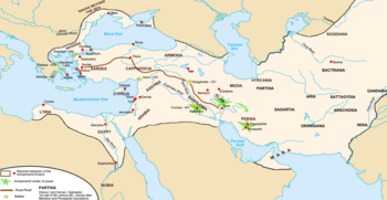
By the time of Herodotus (475 BC) the Persian Royal Road ran some 2,857 km from the city of Susa on the lower Tigris to the port of Smyrna (modern Izmir in Turkey) on the Aegean Sea. It was maintained and protected by the Achaemenid empire (700-330 BC) and had postal stations and relays at regular intervals. By having fresh horses and riders ready at each relay, royal couriers could carry messages the entire distance in 9 days, though normal travellers took about three months. This Royal Road linked into many other routes. Some of these, such as the routes to India and Central Asia, were also protected by the Achaemenids, encouraging regular contact between India, Mesopotamia and the Mediterranean.
Hellenistic Conquests
The first major step in opening the Silk Road between the East and the West came with the expansion of Alexander the Great deep into Central Asia, as far as Ferghana at the borders of the modern-day Xinjiang region of China, where he founded in 329 BC a Greek settlement in the city of Alexandria УAlexandria The FurthestФ, Khujand (formerly Leninabad), in the state of Tajikistan.
When Alexander the GreatТs successors took control of Egypt in 323 BC, they began to actively promote trade with Mesopotamia, India, and East Africa through their ports on the Red Sea coast, as well as overland. The Greeks were to remain in Central Asia for the next three centuries. They kept expanding eastward reaching and going beyond the city of УAlexandria The FurthestФ. There are indications that he may have led expeditions as far as Kashgar in Chinese Turkestan, leading to the first known contacts between China and the West around 200 BC.
The Roman Empire and Silk
 Menade in silk dress, Naples National Museum.
Soon after the Roman conquest of Egypt in 30 BC, regular communications and trade between India, Southeast Asia, Sri Lanka, China, the Middle East, Africa and Europe blossomed on an unprecedented scale. Land and maritime routes were closely linked, and novel products, technologies and ideas began to spread across the continents of Europe, Asia and Africa. Intercontinental trade and communication became regular, organized, and protected. Intense trade with the Roman Empire followed soon, confirmed by the Roman craze for Chinese silk even though the Romans thought silk was obtained from trees:
УThe Seres (Chinese), are famous for the woolen substance obtained from their forests; after a soaking in water they comb off the white down of the leavesЕ So manifold is the labour employed, and so distant is the region of the globe drawn upon, to enable the Roman maiden to flaunt transparent clothing in publicФ (Pliny the Elder (23Ц79, The Natural History).
The Senate issued, in vain, several edicts to prohibit the wearing of silk, on economic and moral grounds: the importation of Chinese silk caused a huge outflow of gold, and silk clothes were considered to be decadent and immoral.
The Hou Hanshu records that the first Roman envoy arrived in China by this maritime route in 166, initiating a series of Roman embassies to China.
Central Asian Commercial & Cultural Exchanges
The heyday of the Silk Road corresponds to that of the Byzantine Empire in its west end, Sassanid Empire Period to Il Khanate Period in the Nile-Oxus section and Three Kingdoms to Yuan Dynasty in the Sinitic zone in its east end. Trade between East and West also developed on the sea, between Alexandria in Egypt and Guangzhou in China, fostering the expansion of Roman trading posts in India. Historians also talk of a УPorcelain RouteФ or УSilk RouteФ across the Indian Ocean. The Silk Road represents an early phenomenon of political and cultural integration due to inter-regional trade.
|
|
|
Under its strong integrating dynamics on the one hand and the impacts of change it transmitted on the other, tribal societies previously living in isolation along the Silk Road or pastoralists who were of barbarian cultural development were drawn to the riches and opportunities of the civilizations connected by the Silk Road, taking on the trades of marauders or mercenaries. Many barbarian tribes became skilled warriors able to conquer rich cities and fertile lands, and forge strong military empires.
The Silk Road gave rise to the clusters of military states of nomadic origins in North China, invited the Nestorian, Manichaean, Buddhist, and later Islamic religions into Central Asia and China, created the influential Khazar Federation and at the end of its glory, brought about the largest continental empire ever: the Mongol Empire, with its political centers strung along the Silk Road realizing the political unification of zones previously loosely and intermittently connected by material and cultural goods.
Mongol Era
The Mongol expansion throughout the Asian continent from around 1215 to 1360 helped bring political stability and re-establish the Silk Road. In the late 13th century, a Venetian explorer named Marco Polo became one of the first Europeans to travel the Silk Road to China. Westerners became more aware of the Far East when Polo documented his travels in Il Milione. He was followed by numerous Christian missionnaries to the East. Luxury goods were traded from one middleman to another, from China to the West, resulting in high prices for the trade goods.
Many technological innovations from the East seem to have filtered into Europe around that time. The period of the High Middle Ages in Europe saw major technological advances, including the adoption through the Silk Road of printing, gunpowder, the astrolabe, and the compass.
Chinese maps and Islamic mapmaking seem to have influenced the emergence of the first practical world maps. Large Chinese junks were also observed by these travelers and may have provided impetus to develop larger ships in Europe.
However, with the disintegration of the Mongol Empire also came discontinuation of the Silk RoadТs political, cultural and economic unity. Turkmeni marching lords seized the western end of the Silk Road Ч the decaying Byzantine Empire. After the Mongol Empire, the great political powers along the Silk Road became economically and culturally separated. Accompanying the crystallization of regional states was the decline of nomad power, partly due to the devastation of the Black Death and partly due to the encroachment of sedentary civilizations equipped with gunpowder.
The Silk Road stopped serving as a shipping route for silk around 1400.
The Great Explorers: Europe Reaching for Asia
The disappearance of the Silk Road following the end of the Mongols was one of the main factors that stimulated the Europeans to reach the prosperous Chinese empire through another route, especially by the sea. Tremendous profits were to be obtained for anyone who could achieve a direct trade connection with Asia.
When he went West in 1492, Christopher Columbus reportedly wished to create yet another Silk Route to China. It was allegedly one of the great disappointments of western nations to have found a continent Уin-betweenФ before recognizing the potential of a УNew World.Ф In 1594 Willem Barents left Amsterdam with two ships to search for the Northeast passage north of Siberia, on to eastern Asia. He reached the west coast of Novaya Zemlya, and followed it northward, being finally forced to turn back when confronted with its northern extremity.
|
|
|
The wish to trade directly with China was also the main drive behind the expansion of the Portuguese beyond Africa after 1480, followed by the powers of the Netherlands and Great Britain from the 17th century. As late as the 18th century, China was usually still considered the most prosperous and sophisticated of any civilization on earth, however its per capita income was low relative to western Europe at that time. Leibniz, echoing the prevaling perception in Europe until the Industrial Revolution, wrote in the 17th century: УEverything exquisite and admirable comes from the East IndiesЕ Learned people have remarked that in the whole world there is no commerce comparable to that of ChinaФ.
In the 18th century, Adam Smith, declared that China had been one of the most prosperous nations in the world, but that it had remained stagnant for a long time and its wages always were low and the lower classes were particularly poor:
УChina has been long one of the richest, that is, one of the most fertile, best cultivated, most industrious, and most populous countries in the world. It seems, however, to have been long stationary. Marco Polo, who visited it more than five hundred years ago, describes its cultivation, industry, and populousness, almost in the same terms in which they are described by travellers in the present times. It had perhaps, even long before his time, acquired that full complement of riches which the nature of its laws and institutions permits it to acquire.Ф (Adam Smith, The Wealth of Nations, 1776).
In effect, the spirit of the Silk Road and the will to foster exchange between the East and West, and the lure of the huge profits attached to it, has affected much of the history of the world during these last three millennia.
Unit 6 Royal Road
The map of Achaemenid Empire and the Royal Road.
The Persian Royal Road was an ancient highway built by the Persian king Darius I of Achaemenid Empire in the 5th Century BC. Darius built the road to facilitate rapid communication throughout his very large empire from Susa to Sardis. His couriers could travel 1,677 miles (2,699 km) in seven days. The Greek historian Herodotus wrote, УThere is nothing in the world that travels faster than these Persian couriers. Ф HerodotusТ praise for these messengers Ч УNeither snow nor rain nor heat nor darkness of night prevents them from accomplishing the task proposed to them with the very utmost speedФ Ч is the inspiration for the unofficial motto of postal carriers.
Course of the Royal Road
The course of the road has been reconstructed from the writings of Herodotus, archeological research, and other historical records. It began in the west in Sardis (about 60 miles east of Izmir in present-day Turkey), traveled east through what is now the middle northern section of Turkey to the old Assyrian capital Nineveh (present-day Mosul, Iraq), then traveled south to Babylon (present-day Baghdad, Iraq). From near Babylon, it is believed to have split into two routes, one traveling northwest then west through Ecbatana and on along the Silk Road, the other continuing east through the future Persian capital Susa (in present-day Iran) and then southeast to Persepolis.
History of the Royal Road
Because the road did not follow the shortest nor the easiest route between the important cities of the Persian Empire, archeologists believe the western-most sections of the road may have originally been built by the Assyrian kings, as the road plunges through the heart of their old empire. More eastern segments of the road (in present-day northern Iran) are coincident with the major trade route known as the Silk Road.
However, Darius I made the Royal Road as it is recognized today by improving the road bed and connecting the parts together in a unified whole, primarily as a quick mode of communication using the kingdom's messengers.
The construction of the road as improved by Darius was of such quality that the road continued to be used into Roman times. A bridge at Diyarbakir, Turkey still stands from this period of the roadТs use.
Unit 7 Inca Road System
|
|
|
Among the many roads and trails constructed in pre-columbian South America, the Inca road system of Peru was the most extensive. Traversing the Andes Mountains and reaching heights of over 5,000 m (16,500 feet) above sea level, the trails connected the regions of the Inca Empire from the northern provincial capital in Quito (Ecuador) past the modern city of Santiago (Chile) in the south. The Inca road system covered approximately 22,500 km (14,000 mi) and provided access to over three million km² of territory.


Major highways of the Inca Empire A chasqui playing a conch shell
Chaski
Since the Incas did not make use of the wheel for transportation, and did not have horses until the arrival of the Spanish in Peru in the 16th century, the trails were used almost exclusively by people walking, sometimes accompanied by pack animals, usually the llama.
The trails were used by the Inca people as a means of relaying messages, carried via knotted-cord quipu (A quipu usually consists of colored spun and plied thread from llama or alpaca hair or cotton cords with numeric and other values encoded by knots in a base 10 positional system. Quipus may have just a few strands, but some have up to 2,000 strands), books, and by memory; and for transporting goods. Messages could be carried by chasqui runners covering as much as 240 km (150 mi) per day.
Each chasqui carried a trumpet made of a conch shell or animalТs horn, a quipu in which information was stored, and a rucksack on his back to hold objects to be delivered. Chasquis worked using a relay system which allowed them to convey messages over very long distances within a short period of time.
There were approximately 2,000 inns placed at even intervals along the trails. The inns provided food, shelter and military supplies to the tens of thousands who traveled the roads. There were corrals for llamas and stored provisions such as corn, lima beans, dried potatoes, and llama jerky. Along the roads, local villagers would plant fruit trees that were watered by irrigation ditches. This enabled chasqui runners and other travelers to be refreshed while on their journeys. Inca rope bridges provided access across valleys.
Many of the trails converge on the center of the empire, the Inca capital city of Cusco. Therefore, it was easy for the Spanish conquistadors to locate the city. Traversing the trails on horseback proved to be difficult and treacherous for the Spanish in their attempts to conquer the Inca Empire.
Main Routes
The most important Inca road was the Camino Real, as it is known in Spanish, with a length of 5,200 km (3,230 mi). It began in Quito, Ecuador, passed through Cusco, and ended in what is now Tucumán, Argentina. The Camino Real traversed the mountain ranges of the Andes, with peak altitudes of more than 5,000 m. El Camino de la Costa, the coastal trail, with a length of 4,000 km (2,420 mi), ran parallel to the sea and was linked with the Camino Real by many smaller routes.
 Inca trail to Machu Picchu.
By far the most popular of the Inca trails for trekking is the Capaq Nan trail, which leads from the village of Ollantaytambo to Machu Picchu, the so-called УLost City of the IncasФ. There are many well-preserved ruins along the way, and hundreds of thousands of tourists from around the world make the three- or four-day trek each year, accompanied by guides.
Inca Rope Bridges

Inca Rope bridges were simple suspension bridges over canyons and gorges to provide access for the Inca Empire. Bridges of this type were suitable for use since the Inca people did not use wheeled transport - traffic was limited to pedestrians and livestock. These bridges were an intrinsic part on the Inca road system and are an excellent example of Inca innovation in engineering. They were frequently used by chasqui runners delivering messages throughout the Inca Empire.
The construction of these bridges amounted to a pair of stone anchors on each side of the canyon with massive cables of woven grass linking these two pylons together. Adding to this construction, two additional cables acted as guardrails. The cables which supported the foot-path were reinforced with plaited branches. This multi-structure system made these bridges strong enough to even carry the Spaniards while riding horses after they arrived. However, these massive bridges were so heavy that they tended to sag in the middle, and this caused them to sway in high winds.
Part of the bridgeТs strength and reliability came from the fact that each cable was replaced every year by local villagers as part of their public service or obligation. In some instances, these local peasants had the sole task of maintaining and repairing these bridges so that the Inca highways or road systems could continue to function.
Renewing the Last Bridge
After a full year of use the last Inca grass-rope bridge sags and must be replaced for safety. Even though there is a modern bridge nearby the folk in the region keep the ancient tradition and skills alive by renewing the bridge. Several family groups have each prepared a number of grass-ropes to be formed into cables at the site, others have prepared mats for decking, and the reconstruction is a communal effort. In ancient times the effort would have been a form of tax, with participants coerced to perform the rebuilding; nowadays the builders have indicated that effort is performed to honor their ancestors and the Pachamama (Earth Mother). The event has also been supported by video productions for the BBC and is becoming a minor tourist attraction, with some small tolls charged for tourists use the road during the festival to walk the newly completed bridge.
Unit 8 Types of Road
Various typesofroads are in use around the world. They range from private access to the stereotypical two-lane highway, to high capacity dual carriageway routes, such as freeways and motorways. The names associated with a particular type of road vary around the world. As a result, the name given to a road in one country could apply to a different type of road in another country.
Definition
A road is an identifiable route or path between two or more places. Roads are typically smoothed, paved, or otherwise prepared to allow easy travel; though they need not be, and historically many roads were simply recognizable routes without any formal construction or maintenance. In urban areas roads may pass along and be named as streets, serving a dual function as urban space and route.
A street is a public parcel of land adjoining buildings in an urban context, on which people may freely assemble, interact, and move about. A street can be as simple as a level patch of dirt, but is more often paved with a hard, durable surface such as cobblestone or brick. Portions may also be smoothed with asphalt, embedded with rails, or otherwise prepared to accommodate non-pedestrian traffic. Examples of streets include pedestrian streets, alleys, and center-city streets too crowded for road vehicles to pass, none of which are usually considered roads.
Medium Capacity
Most countries have major roads of medium capacity designed for automobile travel that connect cities, places, other routes, or other significant points of interest. These routes are usually known by the name given to an official class of road, specific to a country. The term highway is used generically in some parts of the world, including the United States of America. Designs of such routes vary widely. They can include some characteristics of freeways and motorways such as multiple lanes of traffic, a median between lanes of opposing traffic, and access control (ramps and grade separation). They can also be as simple as a two-lane shoulderless road.
2+1 roads are an innovation used in Denmark and Sweden since the 1990s. They are being constructed in other countries, such as Ireland. They involve a road with a single divided carriageway, with two lanes in one direction, and one lane in the other. The format switches every few kilometres to have the two lane section on the other side of the road.

