1. ¬иди негативних процес≥в у екосистемах, що можуть бути ви€влен≥ методами аерокосм≥чного мон≥торингу
- деградац≥€ рослинного покриву, недостатн€ к≥льк≥сть вологовм≥щенн€ дл€ вегетац≥њ рослин;
- недостатн≥й вм≥ст гумусу ірунтових масив≥в;
- засоленн€ ірунту;
- на€вн≥сть важких елемент≥в (забрудненн€ ірунтового покриву).
¬с≥ характеристики таких процес≥в ви€вл€ютьс€ шл€хом отриманн€ коеф≥ц≥Їнту в≥дбитт€, що визначаЇтьс€ за формулою:
ρ = ‘ρ/‘0,
де ‘ρ Ц пот≥к оптичного випром≥нюванн€, що в≥дбилос€ в≥д даноњ поверхн≥ в даному напр€мку;
‘0 Ц пот≥к оптичного випром≥нюванн€, що падаЇ на цю поверхню.
¬важаЇмо, що природн≥ поверхн≥ Ї ортотропними, тобто випром≥нюванн€ розс≥юЇтьс€ однаково у вс≥х напр€мках. „ерез це в≥дбиванн€ ρ залежить в≥д геометр≥њ спостереженн€, зокрема в≥д кут≥в пад≥нн€ q≥ ≥ в≥дбитт€ qr оптичного випром≥нюванн€ ≥ азимута f.
ѕри цьому потр≥бно враховувати нер≥вн≥сть п≥дстилаючоњ поверхн≥.
ритер≥й –елЇ€  . ¬ цьому випадку поверхн€ вважаЇтьс€ достатньо р≥вною, щоб в≥дбитт€ було дзеркальним.
Х ¬плив ірунтових частинок, розм≥р €ких перевищуЇ 2 мм, на в≥дбитт€ ірунту незначний.
Х ћожна стверджувати, що дл€ частинок, розм≥ри €ких становл€ть 2-10 мм, коеф≥ц≥Їнт в≥дбитт€ майже сталий.
Х ƒр≥бн≥ ж частинки суттЇво впливають на в≥дбиванн€ ірунту, причому в≥дбитт€ ірунту зменшуЇтьс€ ≥з зб≥льшенн€м розм≥р≥в частинок.
ѕрограма Landsat маЇ так≥ ≥нструменти Thematic Mapper (TM) ≥ Multi-Spectral Scanner (MSS).
Х ƒ≥л€нка MSS4: 500-600 нм, зелена область.
ѕовТ€зана з поглинанн€м хлороф≥лу ≥ в≥дпов≥даЇ за в≥дбитт€ здорових рослин. р≥м того, њњ доц≥льно використовувати дл€ картографуванн€ водойм.
Х ƒ≥л€нка MSS5: 600-700 нм, червона область. ÷ю смугу, де в≥дбуваЇтьс€ поглинанн€ хлороф≥лу в здорових зелених рослинах, варто використовувати дл€ розп≥знаванн€ рослин, визначенн€ границь ≥ контур≥в ірунтових поверхонь ≥ геолог≥чних утворень.
Х ƒ≥л€нка MSS6: 70-800 нм, в≥дбивальна ≥нфрачервона область. ¬икористовуЇтьс€ дл€ оц≥нки вегетац≥йноњ б≥омаси, ≥дентиф≥кац≥њ урожаю ≥ окреслюванн€ границь розпод≥лу рослинних, ірунтових ≥ водних площ.
Х ƒ≥л€нка MSS7: 800-1100 нм, в≥дбивальна ≥нфрачервона область. ¬живаЇтьс€ дл€ огл€ду рослинних покрив≥в ≥ оц≥нки проникненост≥ туман≥в.
Х ƒ≥л€нка “ћ1: 450-520 нм, блакитна область. ¬икористовуЇтьс€ дл€ картографуванн€ прибережних площ, розп≥знаванн€ границь розпод≥лу м≥ж ірунтом ≥ рослинн≥стю, детектуванн€ культурних пос≥в≥в.
Х ƒ≥л€нка “ћ2: 520-600 нм, зелена область. ¬≥дпов≥даЇ в≥дбиванню здорових рослин, може використовуватис€ також дл€ ≥дентиф≥кац≥њ культурних пос≥в≥в.
Х ƒ≥л€нка “ћ3: 630-690 нм, червона область. ¬живаЇтьс€ дл€ визначенн€ ірунтових ≥ геолог≥чних границь, а також площ культурних пос≥в≥в.
Х ƒ≥л€нка “ћ4: 760-900 нм, в≥дбивальна ≥нфрачервона область. ¬икористовуЇтьс€ дл€ визначенн€ вегетац≥йноњ б≥омаси, ≥дентиф≥кац≥њ урожаю ≥ окресленн€ границь розпод≥лу ірунтових, рослинних ≥ водних масив≥в.
|
|
|
Х ƒ≥л€нка “ћ5: 1,55-1,74 мкм, середн€ ≥нфрачервона область. орисна дл€ вивченн€ впливу посух на урожай ≥ анал≥зу стану рослинних покрив≥в. р≥м того, може бути використана дл€ розп≥знаванн€ хмар, сн≥гу, льоду.
Х ƒ≥л€нка “ћ6: 10.40-12.50 мкм, теплова ≥нфрачервона область. ¬живаЇтьс€ дл€ оц≥нки впливу стрес≥в на рослинн≥ покриви ≥ урожай, зокрема теплових фактор≥в та ≥нсектицид≥в. ћоже бути застосована дл€ визначенн€ м≥сцевоњ геотермальноњ активност≥.
Х ƒ≥л€нка “ћ7: 2,08-2,35 мкм, середн€ ≥нфрачервона область. ÷€ смуга важлива дл€ розп≥знаванн€ геолог≥чних утворень ≥ визначенн€ ірунтових границь, а також дл€ к≥льк≥сноњ оц≥нки в ірунт≥ ≥ рослинах.
2. ќсобливост≥ аерокосм≥чного мон≥торингу стану рослинност≥
’арактерною ознакою рослинност≥ та њњ стану Ї спектральна в≥дбиваюча здатн≥сть, що характеризуЇтьс€ великими в≥дм≥нност€ми у в≥дображенн≥ випром≥нюванн€ р≥зних довжин хвиль. «нанн€ про зв'€зок структури ≥ стану рослинност≥ з њњ спектральними в≥дбивними зд≥бност€ми дозвол€ють використовувати аерокосм≥чн≥ зн≥мки дл€ картографуванн€ та ≥дентиф≥кац≥њ тип≥в рослинност≥ ≥ њх стресового стану.
Ќайб≥льш попул€рний ≥ часто використовуваний ≥ндекс - NDVI (Normalized Difference Vegetation Index) - нормал≥зований р≥зницевий ≥ндекс рослинност≥, вперше був описаний Rouse BJ в 1973 р - простий к≥льк≥сний показник к≥лькост≥ фотосинтетично активноњ б≥омаси (зазвичай названий вегетац≥йним ≥ндексом). ќдин з найпоширен≥ших ≥ використовуваних ≥ндекс≥в дл€ вир≥шенн€ завдань, що використовують к≥льк≥сн≥ оц≥нки рослинного покриву.
≤ндекс обчислюЇтьс€ за наступною формулою:
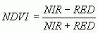
де NIR - коеф≥ц≥Їнт в≥дбитт€ в ближн≥й ≥нфрачервон≥й област≥ спектра;
RED - коеф≥ц≥Їнт в≥дбитт€ в червон≥й област≥ спектра.
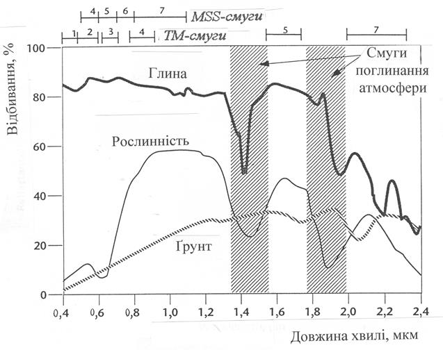
–озрахунок NDVI базуЇтьс€ на двох найб≥льш стаб≥льних (не залежних в≥д ≥нших фактор≥в) д≥л€нках спектральноњ кривоњ в≥дбитт€ судинних рослин. ” червон≥й област≥ спектру (0,6-0,7 мкм) лежить максимум поглинанн€ сон€чноњ рад≥ац≥њ хлороф≥лом вищих судинних рослин, а в ≥нфрачервон≥й област≥ (0,7-1,0 мкм) перебуваЇ область максимального в≥дбитт€ кл≥тинних структур листа. “обто висока фотосинтетична активн≥сть (пов'€зана, €к правило, з густою рослинн≥стю) веде до меншого в≥дбитт€ в червон≥й област≥ спектра ≥ б≥льшого в ≥нфрачервон≥й (рис.3).
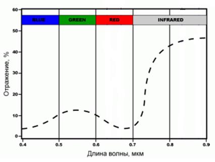
–ис. 3. ƒ≥л€нки характеристичноњ кривоњ в≥дбитт€ рослинност≥ (усередненоњ), що використовуютьс€ дл€ розрахунку NDVI c допомогою даних MODIS
—п≥вставленн€ цих показник≥в один до одного дозвол€Ї ч≥тко в≥докремлювати й анал≥зувати рослинн≥ в≥д ≥нших природних об'Їкт≥в. ¬икористанн€ не просто самого в≥дношенн€, а нормал≥зованоњ р≥зниц≥ м≥ж м≥н≥мумом ≥ максимумом в≥дбитт€ зб≥льшуЇ точн≥сть вим≥рювань, дозвол€Ї зменшити вплив таких €вищ €к в≥дм≥нност≥ в осв≥тленост≥ зн≥мка, хмарност≥, димки, поглинанн€ рад≥ац≥њ атмосферою та ≥н.
ƒл€ рослинност≥ ≥ндекс NDVI приймаЇ позитивн≥ значенн€, ≥ чим б≥льше зелена ф≥томаса, тим вони вищ≥. Ќа значенн€ ≥ндексу впливаЇ також видовий склад рослинност≥, њњ з≥мкнут≥сть, стан, експозиц≥€ ≥ кут нахилу поверхн≥, кол≥р ірунту п≥д розр≥дженою рослинн≥стю. ≤ндекс пом≥рно чутливий до зм≥н ірунтового фону, кр≥м випадк≥в, коли густота рослинного покриву нижче 30%. ≤ндекс може приймати значенн€ в≥д -1 до 1. ƒл€ зеленоњ рослинност≥ ≥ндекс зазвичай приймаЇ значенн€ в≥д 0,2 до 0,8.
NDVI може бути розрахований на основ≥ будь-€ких зн≥мк≥в високого, середнього або низького дозволу, €к≥ мають спектральн≥ канали в червоному (0,55-0,75 мкм) ≥ ≥нфрачервоному д≥апазон≥ (0,75-1,0 мкм). јлгоритм розрахунку NDVI вбудований практично в ус≥ поширен≥ пакети програмного забезпеченн€, пов'€зан≥ з обробкою даних дистанц≥йного зондуванн€ (ArcView Image Analysis, ERDAS Imagine, ENVI, Ermapper, Scanex MODIS Processor, ScanView та ≥н.).
|
|
|
3. ¬изначенн€ властивостей ірунт≥в (вологост≥ ірунту та вм≥сту гумусу в ірунт≥, засоленн€ ірунту).
Ќа в≥дбиванн€ ірунту суттЇво впливають вм≥ст гумусу, оксид≥в зал≥за ≥ р≥зноман≥тних св≥тлозабарвлених субстанц≥й (сполук кремн≥ю ≥ алюм≥н≥ю, карбонат≥в кальц≥ю тощо).
ћетодом дистанц≥йного зондуванн€ можна визначити розпод≥л вологост≥ на обран≥й д≥л€нц≥. “еоретичним п≥дірунт€м цього методу Ї специф≥чний характер спектрального в≥дбитт€ рослинност≥ та в≥дкритого ірунту у видимому, близькому ≥нфрачервоному (NIR) та середньому ≥нфрачервоному (SWIR) д≥апазонах, зумовлений саме в≥дсутн≥стю поглинанн€ оптичного випром≥нюванн€ вод€ною парою на хвил€х 0,8-0,9 та 1,6-1,7 мкм. ƒл€ оц≥нюванн€ вологост≥ визначаютьс€ показники, що базуютьс€ на р≥зниц€х коеф≥ц≥Їнт≥в спектрального в≥дбитт€ r 0 поверхонь у видимому та ≥нфрачервоному спектральних д≥апазонах.
¬становлено, що найвища корел€ц≥€ ≥з вологовм≥щенн€м ірунту спостер≥гаЇтьс€ дл€ нормал≥зованого водного ≥ндексу NWI (Normalized Water Index):
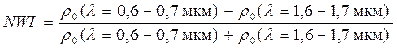 .
.
ƒл€ оц≥нюванн€ зволоженост≥ ірунтового покритт€ залучаЇмо багатоспектральний косм≥чний зн≥мок з супутника Landsat Ц 7 видимого та близького ≥нфрачервоного спектральних д≥апазон≥в. ƒл€ цього сенсора попереднЇ сп≥вв≥дношенн€ набуваЇ вигл€ду:
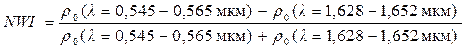 ,
,
де вказан≥ довжини хвиль в≥дпов≥дають другому та п'€тому спектральним каналам супутника Landsat Ц 7.
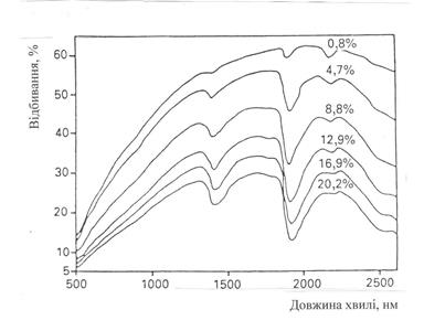
¬ ц≥лому, зб≥льшенн€ вм≥сту води в ірунт≥ може зменшувати в≥дбиванн€ ірунту в 2-3 рази без зм≥ни форми кривоњ спектра в≥дбиванн€. ¬еличини ρо (λ =1,4Ц1,5мкм), ρо (λ =1,8Ц1,9мкм), ρо (λ =2,08Ц2,3мкм) можуть бути використан≥ €к спектральн≥ ≥ндекси.
√умус характеризуЇтьс€ низьким в≥дбиванн€м ≥ при великих концентрац≥€х в≥дпов≥даЇ за с≥ро-чорний кол≥р ірунту. ¬≥дбитт€ гумусу монотонно зростаЇ в≥д 0,4 мкм до 0,75 мкм.
ƒл€ к≥льк≥сноњ оц≥нки впливу гумусу використовують €к спектральн≥ ≥ндекси величини ρо (0,73 мкм ) або ρо [(0,73 Ц 0,43 мкм )]/ ρо (0,73 мкм ).
ћожливо також застосуванн€ величин ρо(0,52 Ц 1,32 мкм ), ρо(1,42-1,48 мкм ), ρо (1,55 Ц 1,75 мкм ), ρо (2,08 Ц 2,32 мкм ).
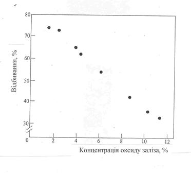
¬ ц≥лому, закис зал≥за надаЇ ірунту голубувато-зеленого кольору (€к це спостер≥гаЇтьс€ у болотистих ірунтах). –≥вень г≥дратац≥њ оксид≥в зал≥за впливаЇ на характер спектрального в≥дбитт€ ірунту: високог≥дратован≥ сполуки зал≥за надають ірунту жовтий кол≥р, а низьког≥дратован≥ Ц с≥ро-коричневий або червонуватий кольори.
¬еличини ρо (0,53 Ц 0,6 мкм ), ρо (0,7 Ц 0,9 мкм ), ρо (1 мкм ), ρо (0,65 Ц 0,4 мкм ) можна використовувати €к спектральн≥ ≥ндекси дл€ оц≥нки сполук зал≥за по в≥дбиттю ірунту.