


—клала викладач
англ≥йськоњ мови
¬ощина ћ.¬.
LESSON 1
1. Read and memorize:
to determine - определ€ть
length - длина
latitude - широта
longitude - долгота
elevation Ц возвышение, высота
sea level Ц уровень мор€
reverse - перевернутый
geodetic - геодезический
curvature Ц кривизна, изгиб
dimension Ц измерение, величина
2. Read and translate the text using the vocabulary:
Surveying
Geodesy is the science of determining accurately the relative locations of points and lines on the earthТs surface and recording them on maps. The positions of these points and lines are determined in terms of length and azimuths of the lines, in terms of co-ordinates, latitude, longitude, and elevation above mean sea level.
Geodesy includes also the reverse operation of discovering and location on the ground points and lines depicted on a surveyorТs map.
Two principal kinds of geodesy are recognized, plane and geodetic. On plane surveying the area which is the subject of survey is regarded as a plane surface, the curvature of the earth being disregarded. In geodetic surveying, which deals with areas of large extent, the curvature of the earth is considered. Higher geodesy has also for its object the exact determination of the dimension and form of the earth.
Make up word combinations from two columns
Relative level
EarthТs point
Sea location
Reverse operation
Ground surveying
Plane surface
Answer the questions
1) What the science is geodesy?
2) What terms are used to determine the position of the points?
3) How many kinds of geodesy are recognized? Name them.
4) What is the subject of plane surveying?
5) What does the higher geodesy deals with?
LESSON 2
1. Read and memorize the words:
Tape - рулетка
To lessen Ц уменьшать, сокращать
Kink Ц перекручиватьс€, свертыватьс€ в петлю
Sleeve Ц муфта, гнездо
Etch Ц гравировать на металле травлением
Rivet - заклепка
Pull Ц нат€гивать
2. Read and translate the text using the vocabulary:
Surveying and drafting instruments Ц tapes and rods
Steel tapes are commonly 25, 50, 75, 100, 200, 300 or 500 ft. long. To 100 ft. they are usually thin steel ribbons, the longer tapes are thicker and narrower, to lessen liability of kinking and to stand rougher usage. The lighter tapes are graduated throughout in feet, tenths, and hundredths; the heavier ones are usually marked by notched sleeves, etchings, or brass rivets at every 1-, 5-, 10-, or 20- ft. point with the last foot on each end divided into tenths or hundredths. When 5, 10, or 20-ft points alone are marked the last 5, 10, or 20-ft is usually graduated at every foot.
Steel tapes fitted with a thermometer for temperature corrections, and with a spring balance for measuring the amount of pull, are used chiefly in city surveying. Broken tapes can be mended by riveting on the back of the tape a piece of the old tape of the same width.
|
|
|
Put down 5 questions to the text.
4. Complete the sentences:
1) Steel tapes are usedЕ
2) Broken tapes can be mendedЕ
3) The heavier tapes are markedЕ..
4) Steel tapes are commonlyЕ
5) The lighter tapes are graduatedЕ
Make the short dialogue using the information from the text.
LESSON 3
1. Read and memorize the words:
Clinometer Ц эклиметр, квадрант
Estate - недвижимость
Reconnoiter - разведывать
Boundary - граница
It should be noted Ц следует заметить
Tally Ц единица счета
Align - выравнивать
Linen tape Ц мерна€ лента
In order to break Ц чтобы не учитывать
Misread Ц прочитать неправильно
2. Read and translate the text using the vocabulary:
Chain Surveying
Land surveying with a chain or steel tape, ranging or surveying poles and a clinometer is amongst the simplest and oldest methods of making plan. It is employed by architects and land surveyors in the preparation of estate plans and is useful for mapping new detail of lesser importance.
|
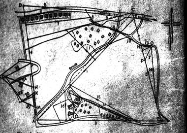
An example of the general procedure is illustrated in Fig.1. The surveyor reconnoiters the ground to be mapped and fixes stations A, B, C, D, etc., so that the straight line joining them runs near to the boundaries of the area.
These lines should form triangles, as this is the only figure which can be plotted from the length of the side alone.
These lines are measured with a chain or steel tape and at the same time perpendicular distances (or offsets) are taken with a linen tape from measured distances along the line, in order to fix the irregular boundaries and other features.
|
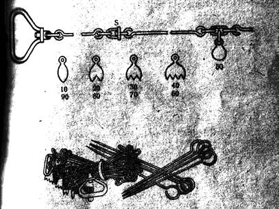
After fixing the principal triangles required to cover the area (Fig.1) Ц there are two of such triangles ABE and ADC Ц the interior details may be fixed by Уbreaking downФ the triangles inwards by lines from measured positions on the principal lines. Measurements of the lines are usually made with a chain consisting of 100 links, each of which is 1 ft long in the case of a 100ft EngineersТ chain, or 0,66ft (7,92in) in a 66ft GunterТs chain. The use of GunterТs chain, in which 100 links equal 66ft or 1 chain facilitates the calculation of areas in acres since 10 sq.chains = 1 acre, as shown in Fig.2.
It should be noted that 60 and 40 tallies are identical and may easily be misread. Observation as to whether the 50 tally is before or after the four-pronged tally will identify the latter as 60 or 40 respectively. Although the tallies for 30 and 70, 20 and 80, 10 and 90 are also identical the difference in length makes a mistake in reading unlikely with reasonable care. The chain length should be carefully aligned by ranging poles and the chain pulled tight in order to bridge small irregularities of the ground.
3. Answer the following questions:
1. What is land surveying?
2. By whom is land surveying employed?
3. What is shown in Fig.1?
4. What is GunterТs chain?
5. What are measurements of the lines made with?
Describe Figs. 1 and 3.
5. Use the following sentence in all forms (negative and interrogative):
The surveyor fixes the stations.
Make the plan of the text
LESSON 4
Read and translate the text
Mine Surveying
|
|
|
Mine surveys are made for the purpose of obtaining data from which to establish direction for proceeding the workings determining the amount of material taken from the mine and the probable amount of available coal or other mineral that can be worked. Graphical representation of mine workings may be made from these data to aid efficient operation of the mine.
The underground surveying is based on the same principles as that on the surface. This method of reading angles and measuring distances, of computing azimuths, bearings, coordinates, and elevations, and of plotting the results are alike in all essentials.
In practical details, however, a number of differences are introduced by certain peculiar conditions under which mine survey must be conducted.
2. Combine the words with their translation:
Mine surveying угол
To aid выработка
Angle азимут
Bearing помогать
Proceeding работа
Working горна€ съемка
Jigsaw sentences
1. as, is based, that, the surface, on, on, the same, the underground, principles, surveying.
2. be, data, from, mine, may, made, of, representation, workings.
4. Answer the questions:
1. What purpose are mine surveys made for?
2. What is based on the principles of surface surveying?
3. Have these two surveying the same methods?

