


ѕодтипы создают категории или группы объектов определенного типа внутри одного класса пространственных объектов. Ёти группы могут по-разному отображатьс€ и также по-разному редактироватьс€. подтипам может быть применено дополнительное поведение, такое как значени€ атрибутов по умолчанию. Ёто позвол€ет каждой группе объектов иметь свои отличные от других значени€ по умолчанию дл€ выбранных полей.
–анее вы создали подтипы на основе высоты тропы дл€ класса пространственных объектов R2Trails. ¬ы продолжите работать с этим классом объектов в этом шаге.
|

ѕримечание: ѕомните, целевой слой Ц это слой или подтип, в котором вы создаете новые объекты.

ќбратите внимание, что в списке ÷елевой слой (Target) два сло€: R2Trails и R2VEG. “ак как в R2VEG нет подтипов, то дл€ этого целевого сло€ нет дополнительного выбора. ќднако, слой R2Trails содержит подтипы и, следовательно, имеет дополнительный выбор под именем сло€. ¬спомните из упражнени€ 5, что вы создали три подтипа по полю ELEV_CLASS. ¬ этом упражнении вы добавите новые тропы в каждую из этих категорий и просмотрите атрибуты по умолчанию и символы отображени€, когда закончите. —начала вы запустите ArcCatalog и просмотрите значени€ по умолчанию дл€ этих трех подтипов.
|
|
|
|
 ¬опрос 3: ѕочему эти выпадающие меню серые?
¬опрос 4: ≈сли вы захотите изменить значение по умолчанию или добавить дополнительный подтип, что вы должны сделать сначала?

|
|
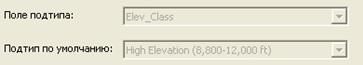
¬опрос 5: акое значение по умолчанию дл€ подтипа HighElevation?
|
¬опрос 6: акое значение по умолчанию дл€ подтипа MediumElevation?
¬опрос 7: акое значение по умолчанию дл€ подтипа Low Elevation?
Ёто те значени€ по умолчанию, которые вы установили дл€ каждого подтипа в предыдущем упражнении. ¬озможно, в предыдущем упражнении вы ввели описани€ на русском €зыке, но здесь видите английские значени€. Ёто произошло от того, сейчас вы работаете с базой Exercise7, а собственные значени€ вводили в базу Exercise5. при желании, можете просмотреть значени€ там.
|
|
|
“еперь, когда вы вспомнили эти значени€, вернитесь в ArcMap дл€ редактировани€ подтипов.
|
¬ы нанесете новые объекты в различные подтипы и просмотрите значени€ по умолчанию.
|
 .
.
|
|
Ќова€ тропа остаетс€ выбранной, показыва€, что это новый объект и нужно обновить его атрибуты.
|
«аметьте, что дл€ пол€ TR_Conditionавтоматически установилось значение Dirt, looserock.

|
|
 и щелкните где-нибудь р€дом с объектом, чтобы сн€ть с него выборку.
¬опрос 8: акого цвета нова€ тропа?

|
|

|
¬опрос 9: —ейчас какое значение TR_Condition?

¬опрос 10: акого цвета нова€ тропа?

|
огда вы изменили значение в поле подтипа, вы также изменили все значени€ по умолчанию, которые установлены. ѕодтипы не только делают отображение данных легче и быстрее, они также упрощают редактирование и делают его более эффективным с помощью значений по умолчанию и целевого сло€. ƒалее вы быстро просмотрите возможности, которые позвол€ют вам изменить способ, которым домены и подтипы отображаютс€ в таблице.
|
|
 »зучите значени€ дл€ пол€ ELEV_CLASS.
¬опрос 11: „то отображаетс€ в поле?
|
|
¬опрос 12: „то отображаетс€ в поле сейчас?
«аметьте, что поле ELEV_CLASS показывает только 1, 2 или 3, исходные целые значени€ дл€ этого пол€. ¬спомните, что поле подтипа должно быть определено как целое поле. огда вы создаете подтипы в классе пространственных объектов, описание, которое вы вводите в ArcCatalog Ц это то, что потом пользователь видит вместо кода. ¬ы можете использовать этот способ, но иногда дл€ понимани€ лучше видеть описани€.
|
|
|
|
|
|

